Chapter 1 - Special Jerome Corridor District (J)
GENERAL PURPOSES
The “Special Jerome Corridor District” established in this Resolution is designed to promote and protect public health, safety and general welfare. These general goals include, among others, the following specific purposes:
(a) to encourage well-designed buildings that complement the built character of the Highbridge, Concourse, Mount Eden, Mount Hope, Morris Heights and University Heights neighborhoods;
(b) to achieve a harmonious visual and functional relationship with the adjacent neighborhoods;
(c) to enhance neighborhood economic diversity by broadening the range of housing choices for residents at varied incomes;
(d) to create a livable community combining housing, retail and other uses throughout the district;
(e) to create a walkable, urban streetscape environment through a mix of ground floor uses;
(f) to create a lively and attractive built environment that will provide daily amenities and services for the use and enjoyment of area residents, workers and visitors;
(g) to provide flexibility of architectural design within limits established to assure adequate access of light and air to the street, and thus to encourage more attractive and economic building forms on zoning lots with irregular shapes and on zoning lots fronting on the elevated rail structure along Jerome and River Avenues; and
(h) to promote the most desirable use of land in accordance with a well-considered plan and thus conserve the value of land and buildings, and thereby protect the City’s tax revenues.
General Provisions
The provisions of this Chapter shall apply within the Special Jerome Corridor District. The regulations of all other Chapters of this Resolution are applicable, except as superseded, supplemented or modified by the provisions of this Chapter. In the event of a conflict between the provisions of this Chapter and other regulations of this Resolution, the provisions of this Chapter shall control. However, for transit-adjacent sites or qualifying transit improvement sites, as defined in Section 66-11 (Definitions), in the event of a conflict between the provisions of this Chapter and the provisions of Article VI, Chapter 6 (Special Regulations Applying Around Mass Transit Stations), the provisions of Article VI, Chapter 6 shall control.
District Plan and Maps
In order to carry out the purposes and provisions of this Chapter, district maps are located in the Appendix to this Chapter and are hereby incorporated and made an integral part of this Resolution. They are incorporated for the purpose of specifying locations where special regulations and requirements, as set forth in the text of this Chapter, apply.
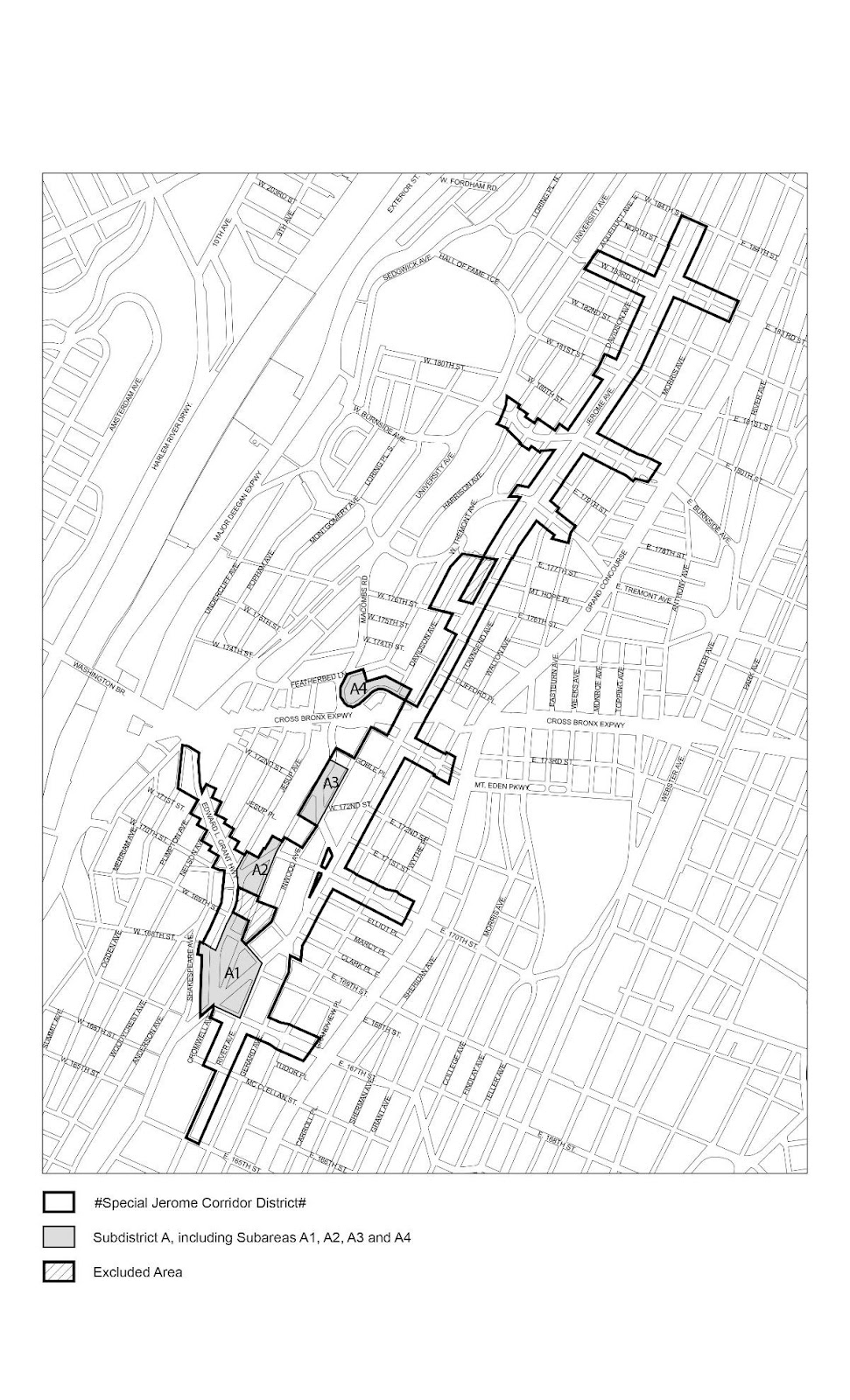
Map 1. Special Jerome Corridor District, Subdistrict and Subareas
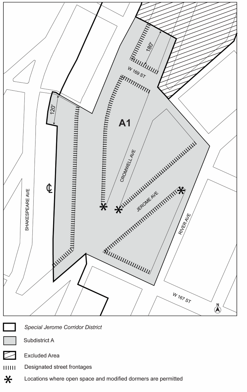
Map 2. Designated locations for street wall continuity and ground floor requirements in Subarea A1
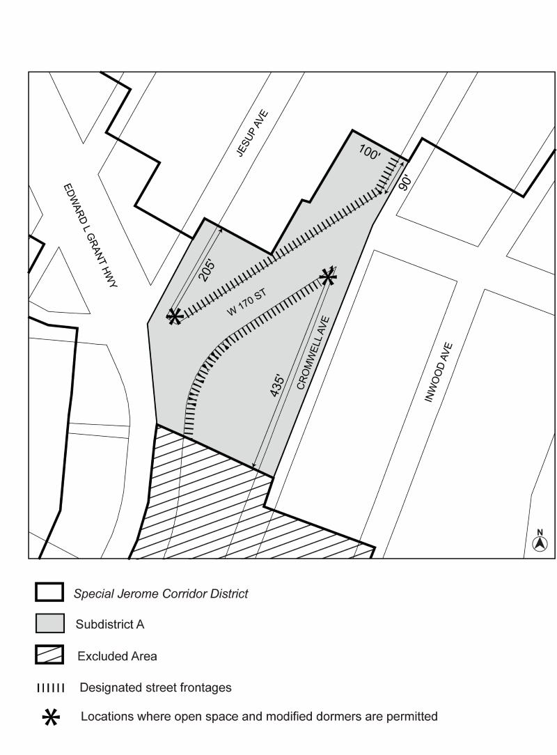
Map 3. Designated locations for street wall continuity and ground floor requirements in Subarea A2
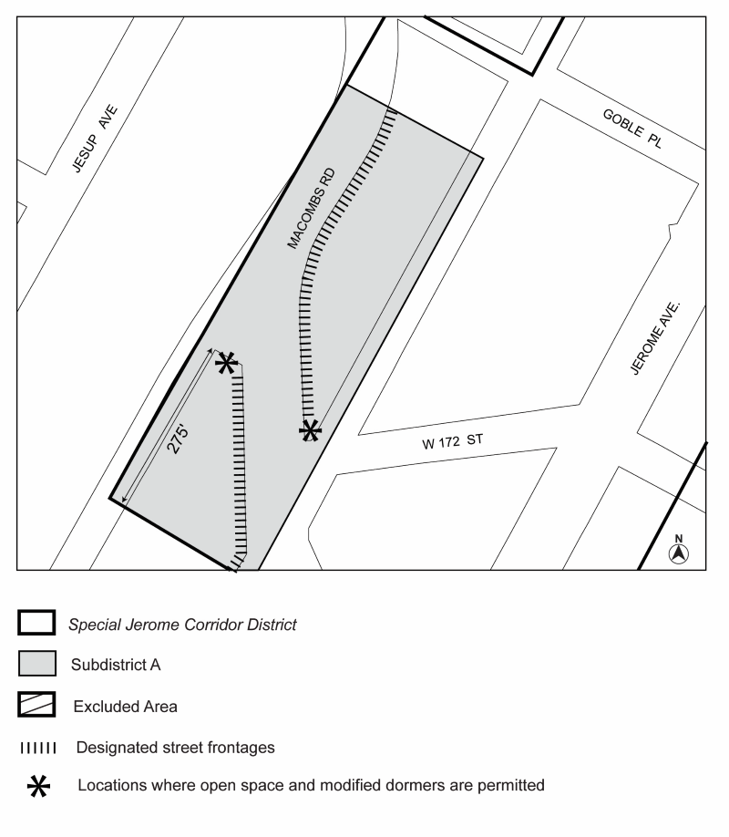
Map 4. Designated locations for street wall continuity requirements in Subarea A3
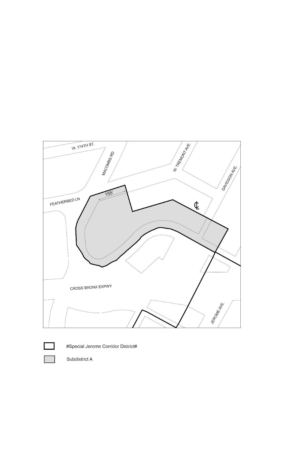
Map 5. Boundary of Subarea A4
Subdistricts and Subareas
To carry out the provisions of this Chapter, Subdistrict A, comprised of Subareas A1, A2, A3 and A4, is established. The location and boundaries of this Subdistrict and Subareas are shown on Map 1 (Special Jerome Corridor District, Subdistrict and Subareas) in the Appendix to this Chapter.
For the purposes of applying the Mandatory Inclusionary Housing Program provisions set forth in Section 27-10 (ADMINISTRATION OF AFFORDABLE HOUSING), inclusive, Mandatory Inclusionary Housing areas within the Special Jerome Corridor District are shown on the maps in APPENDIX F of this Resolution.
SPECIAL USE REGULATIONS
Within the Special Jerome Corridor District, the underlying use regulations shall apply.
In C1 or C2 Districts mapped within R7 or R8 Districts and located along the elevated rail structure on Jerome or River Avenues, the provisions of Section 32-421 (Limitation on floors occupied by commercial uses) shall be modified for buildings containing residences as follows. The limitations set forth in paragraph (a) of such Section shall be modified to apply to buildings constructed before March 22, 2018.
SPECIAL BULK REGULATIONS
The underlying bulk regulations are modified by the provisions of this Section.
Special Yard Regulations
In Commercial Districts, for zoning lots or portions thereof, with street lines along the elevated rail structure on Jerome or River Avenues and within 100 feet of such street lines, the permitted obstructions set forth in Section 33-23 (Permitted Obstructions in Required Yards or Rear Yard Equivalents) shall be modified to permit any building or portion of a building used for any permitted use other than residences, to be a permitted obstruction within a required yard, rear yard equivalent or other open space required pursuant to the provisions of Section 33-20 (YARD REGULATIONS), inclusive, or Section 33-30 (OTHER SPECIAL PROVISIONS FOR REAR YARDS), inclusive, provided that the height of such portion of a building shall not exceed two stories, excluding basement, nor in any event 30 feet above curb level. Any allowance for other permitted obstructions above a building in a rear yard or rear yard equivalent set forth in Section 33-23, shall be permitted above such modified height limitations.
For zoning lots in R8A Districts, or Commercial Districts mapped within, or with a residential equivalent of an R8A District, within 100 feet of a wide street located outside of Mandatory Inclusionary Housing areas, the underlying floor area provisions applicable to an R8 District within 100 feet of a wide street shall apply.
For zoning lots, or portions thereof, within 100 feet of street lines along the elevated rail structure on Jerome or River Avenues, and located outside Subdistrict A, the underlying height and setback provisions are modified by the provisions of this Section.
- Street wall location
The street wall location provisions of paragraph (a)(1) of Section 35-643 (Special provisions in other geographies) shall apply.
Any open space between a street wall and a street line along the elevated rail structure on Jerome or River Avenues shall comply with the special open space provisions of paragraph (a) of Section 141-32. - Base heights, maximum building heights
The underlying height and setback provisions of Section 35-63 (Height and Setback Requirements in Commercial Districts with R6 Through R12 Equivalency), inclusive, shall apply, as modified by the provisions of paragraph (a) of Section 35-643 (Special provisions in other geographies). However, for street walls facing the elevated rail structure, beyond 75 feet of the corner of streets intersecting Jerome or River Avenues, the maximum base height shall be 30 feet. - Required and permitted articulation
For street walls fronting the elevated rail structure on Jerome or River Avenues with widths exceeding 100 feet, a minimum of 20 percent of the surface area of such street walls above the level of the second story, or a height of 30 feet, whichever is lower, shall either recess or project a minimum of three feet from the remaining surface of the street wall. Any such projections shall be considered a permitted obstruction into a required setback, and the depth of such projections along the elevated rail structure shall not exceed three feet.
In addition, the underlying dormer provisions of paragraph (b) of Section 23-413 (Permitted obstructions in certain districts) shall be modified for portions of buildings facing the elevated rail structure, so that above the maximum base height set forth in paragraph (b) of this Section, dormers shall be permitted only within 75 feet of a corner.
In Subdistrict A, as shown on Map 1 in the Appendix to this Chapter, the underlying height and setback provisions are modified by the provisions of this Section.
- Street wall location
- Along the elevated rail structure
For street walls, or portions thereof, within 100 feet of street lines along the elevated rail structure on Jerome or River Avenues, the street wall location provisions of paragraph (a)(1) of Section 35-643 (Special provisions in other geographies) shall apply. - Along designated streets
In Subareas A1 through A3, along the streets designated on Maps 2 through 4 in the Appendix to this Chapter, the following shall apply:- In Commercial Districts
In Commercial Districts, the street wall location provisions of paragraph (b) of Section 35-631 shall apply, except that the street wall shall extend to at least a height of 30 feet, or the height of the building, whichever is lower. In addition, above a height of 30 feet, at least 50 percent of the aggregate width of street walls shall be located within eight feet of the street line and shall extend to at least a minimum base height of 60 feet, or the height of the building, whichever is lower.
The remaining aggregate width of street walls may be recessed beyond 15 feet of the street line, provided that any such recesses deeper than 10 feet along a wide street or 15 feet along a narrow street are located within an outer court.
In the corner locations designated on Maps 2 and 3, an open space may be provided within 75 feet of the corner, pursuant to the provisions of paragraph (b) of Section 141-33. - In Residence Districts
For street walls, or portions thereof, located in Residence Districts, at least 70 percent of the aggregate width of street walls shall be located within 15 feet of the street line and shall extend to at least the minimum base height set forth in paragraph (b) of this Section, or the height of the building, whichever is lower.
The remaining aggregate width of street walls may be recessed beyond 15 feet of the street line, provided that any such recesses deeper than 10 feet along a wide street or 15 feet along a narrow street are located within an outer court.
The underlying allowances for street wall articulation, set forth in paragraph (d) of Section 23-431 shall be permitted to project or recess, where applicable, beyond the street wall locations established in this paragraph.
In the corner locations designated on Map 4, an open space may be provided within 75 feet of the corner, pursuant to the provisions of paragraph (b) of Section 141-33.
- In Commercial Districts
- Along other streets
In Subareas A1 through A3, along streets that are not designated on Maps 2 through 4, and in Subarea A4, along all streets, no street wall location provisions shall apply, and no minimum base heights shall apply.
- Along the elevated rail structure
- Base heights and maximum building heights
The underlying height and setback regulations shall apply, except as modified below:- for street walls facing the elevated rail structure, beyond 75 feet of the corner of streets intersecting Jerome or River Avenues, the maximum base height shall be 30 feet;
- the setback provisions of Section 23-433 (Standard setback regulations) shall apply except that for portions of buildings or other structures along Cromwell Avenue located beyond 200 feet from a corner, a minimum setback with a depth of at least 30 feet shall be provided;
- In R9A Districts, or in Commercial Districts mapped within R9A Districts:
- the maximum base height shall be 125 feet;
- above the required setback, the height of a building shall not exceed a maximum transition height of 175 feet;
- where the lot coverage of all buildings on the zoning lot above the maximum transition height has been reduced to 50 percent on zoning lots with a lot area less than or equal to 15,000 square feet, 40 percent on zoning lots with a lot area greater than 15,000 square feet but less than 30,000 square feet, and 30 percent for all other zoning lots, a building may rise to a maximum building height of 225 feet. The maximum street wall width of any story above the maximum transition height shall not exceed 165 feet and, where two or more non-contiguous portions of a building exist at the same level above the maximum transition height, such portions shall provide a minimum distance of 60 feet between facing walls at any point.
- Required and permitted articulation
In Subareas A1 through A3, along streets designated in Maps 2, 3 and 4 in the Appendix to this Chapter, for street wall widths exceeding 100 feet, a minimum of 20 percent of the surface area of street walls above the level of the second story, or a height of 30 feet, whichever is lower, shall either recess or project a minimum of three feet from the remaining surface of the street wall. Any such projections shall be considered a permitted obstruction into a required setback, provided that any projections with a depth greater than five feet shall be considered a dormer.
In addition, the underlying dormer provisions of paragraph (b) of Section 23-413 (Permitted obstructions in certain districts) shall apply, except that in Subareas A1 through A3, for street walls intersecting within 100 feet of the corners designated on Maps 2, 3 and 4, and irrespective of the width of the street wall below the maximum base height, dormers shall be permitted within 100 feet of such intersecting street walls. Such dormers need not decrease in width as the height above the maximum base height increases.
Any dormers or projections provided in accordance with this paragraph need not be included in the maximum lot coverage permitted above the maximum transition height, nor be included in the maximum street wall width of a story.
For zoning lots in R8A Districts, or in Commercial Districts mapped within, or with a residential equivalent of an R8A District, within 100 feet of a wide street located outside of Mandatory Inclusionary Housing areas, the underlying height and setback provisions applicable to an R8 District within 100 feet of a wide street shall apply. However, sky exposure plane buildings shall not be permitted, and the additional height allowances for eligible sites set forth in Section 23-434 (Height and setback modifications for eligible sites) shall not apply.
Streetscape Regulations
The underlying ground floor level streetscape provisions set forth in Section 32-30 (STREETSCAPE REGULATIONS), inclusive, shall apply, except that ground floor level street frontages along Jerome Avenue or River Avenue, or portions thereof, as well as designated street frontages shown on Maps 2 or 3 in the Appendix to this Chapter, shall be considered Tier C street frontages.
Defined terms in this Section shall include those in Sections 12-10 and 32-301.
Along the elevated rail structure on Jerome or River Avenues, where open space is provided between the street line of the zoning lot and the street wall of a building facing the elevated rail structure, or in Subdistrict A, for Subareas A1 through A3, where open space is provided between the street wall and the corner at a location designated on Maps 2, 3 or 4 in the Appendix to this Chapter, the provisions of Section 22-613 (Front yard planting requirements) shall apply to all buildings, whether the ground floor is occupied by residential uses or non- residential uses, subject to the modifications of this Section.
- Along the elevated rail structure
Along the elevated rail structure on Jerome or River Avenues, a sidewalk widening, built to Department of Transportation standards, may be provided as an alternative to planting, provided that the area that would otherwise be allocated to planting, measured in square feet, is allocated to streetscape amenities, including, but not limited to, trees, bicycle racks, benches or wall treatment, that are provided along such sidewalk widening, as set forth below.
Where benches are provided as an alternative to such planting, the length of such benches shall not exceed, in the aggregate, 15 feet per every 50 feet of street wall frontage. Where bicycle racks are provided, such racks shall be oriented so that the bicycles are placed parallel to the street wall, and the width of such bicycle racks shall not exceed, in the aggregate, 10 feet per every 50 feet of street wall frontage. Such benches or bicycle racks shall be located entirely within the zoning lot, and each bench or bicycle rack so provided shall be equivalent to 15 square feet of planted area.
Where trees, and associated tree pits are provided as an alternative, the minimum depth of any open space between the street wall and street line shall be eight feet. Each tree provided shall be equivalent to 15 square feet of planted area.
Where a wall treatment is provided as an alternative, it shall be in the form of permitted signs, graphic or sculptural art, rustication, decorative screening or latticework, or living plant material along the street wall. Such wall treatment shall extend to a height of at least 10 feet, as measured from the level of the adjoining sidewalk or grade, and shall have a minimum width of 10 feet, as measured parallel to the street wall. Portions of a street wall providing such wall treatment may satisfy applicable requirements of Section 141-32, or the planting requirement directly in front of such street wall.
Where planting is provided, the minimum depth of open space between the street line and the street wall shall not be less than three feet. - In Subdistrict A
In Subdistrict A, where open space is provided between the street wall and the intersection of two streets, pursuant to paragraph (a)(2) of Section 141-23, streetscape amenities may be provided as an alternative to planting, provided that the area that would otherwise be allocated to planting, measured in square feet, is allocated to trees, benches, or tables and chairs, as set forth below. However, planting shall not be reduced to less than 20 percent of the area of the open space.
Each bench provided shall be equivalent to 10 square feet of planted area, and each set of tables and at least two chairs shall be equivalent to 15 square feet of planted area. Seating shall be publicly accessible, unless tables and chairs are associated with an open eating or drinking establishment on the zoning lot. The area under such seating shall be paved with permeable materials and shall either abut the adjoining sidewalk or be connected to such sidewalk by a circulation path at least five feet wide that is also paved with permeable materials.
Each tree and associated tree pits provided shall be equivalent to 15 square feet of planted area, and shall be located at least 10 feet from any building wall or the adjoining sidewalk.
Where planting is provided, the minimum depth of a planted bed shall not be less than three feet.
In no event shall chain link fencing or barbed or razor wire be permitted in any open space provided pursuant to this Section.
The underlying parking provisions are modified by the provisions of this Section.
Location of Curb Cuts
In all districts, for zoning lots existing on March 22, 2018, with frontage along Edward L. Grant Highway, West 170th Street, or the portions of Jerome or River Avenues with an elevated rail structure, and fronting along other streets, no curb cut accessing off-street parking spaces or loading spaces shall be permitted along such streets, as applicable.
APPENDIX
Map 1. Special Jerome Corridor District, Subdistrict and Subareas
Map 2. Designated locations for street wall continuity and ground floor requirements in Subarea A1
Map 3. Designated locations for street wall continuity and ground floor requirements in Subarea A2
Map 4. Designated locations for street wall continuity requirements in Subarea A3
Map 5 Boundary of Subarea A4

